Geography across the Key Stages at Teynham
Geography is lead by Mrs Ellis-Jones.
The purpose of geography teaching at Teynham is to encourage our children to be inspired by, and curious about, the world around them, both at a school and local level and – as our children progress through KS1 and into KS2 – at a wider national, and international level. We aim to give our children memorable experiences in our amazing world, as well as to equip them with the geographical skills that will allow them to explore their own research questions, and a core set of geographical knowledge about both the human and physical aspects of life on Earth.
Our KS1 and KS2 geography objectives are taught as part of cross-curricular topic work, encompassing not only core geography lessons, but also English and – depending on year group – art and DT. The main geography topics are covered in terms 3 and 4, although there are introductory topics in terms 1 and 2. Geography in EYFS is covered throughout the year as part of the ‘Understanding the World’ Early Learning Goal, and more widely by encouraging the children’s developing sense of place and space.
Each term, teachers share a ‘knowledge organiser’ (KO) with their children, helping to provide a context for the children’s learning, and to demonstrate the learning journey and expectations for that term. Here is a sample of KOs from across the year groups, which give a flavour of the breadth of topics covered:
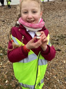
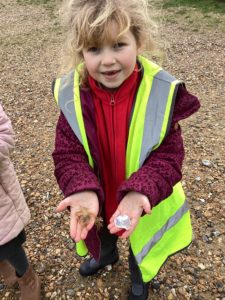
Field trips and fieldwork are an integral part of geography at Teynham School. Examples of such opportunities in a given year might include: geography field trips to Broadstairs (EYFS), Canterbury (Y1), Herne Bay (Y2) or London (Y6). Field work is undertaken in the school grounds, in Teynham village more widely, and throughout Kent. Recent field work has been undertaken by year 5 at Brogdale Orchards, or by year 4 at Riverside Country Park, although we aim to ensure that field work is incorporated into our wider geography curriculum as a matter of course, so our children will often be out-and-about in the local area with clip boards and related equipment!